The text that follows is a PREPRINT.
Please cite
as:
Laurance, W.F., M.A. Cochrane, S.
Bergen, P.M. Fearnside, P. Delamônica, C. Barber, S. D’Angelo and T.
Fernandes. 2001. The Future of the Brazilian Amazon. Science 291:
438-439.
ISSN: 0036-8075
Copyright: American
Association for the Advancement of Science (AAAS)
The original publication is available at http://www.sciencemag.org
<free from publisher
in online format>
POLICY
FORUM: ENVIRONMENT

The
Future of the Brazilian Amazon
William F. Laurance*, Mark A. Cochrane, Scott Bergen, Philip M. Fearnside,
Patricia Delamônica, Christopher Barber, Sammya D’Angelo, and Tito Fernandes
(main text: 1339 words [1945 words overall], not including attached material to be archived on Science’s website)
W. Laurance is a research scientist at the Smithsonian Tropical Research Institute, Apartado 2072, Balboa, Panamá, and Biological Dynamics of Forest Fragments Project (BDFFP), National Institute for Amazonian Research (INPA), C.P. 478, Manaus, AM 69011-970, Brazil. M. Cochrane is a research scientist at the Basic Science and Remote Sensing Initiative (BSRSI), Michigan State University, East Lansing, MI 48823. S. Bergen is a doctoral candidate at the Department of Forest Science, Oregon State University, Corvallis, OR 97331. P. Fearnside is a research scientist at the INPA Ecology Department. P. Delamônica is assistant director of the BDFFP, C. Barber is a research associate at BSRSI, and S. D’Angelo and T. Fernandes are BDFFP research assistants.
*To whom correspondence should be addressed. Email: wfl@inpa.gov.br
The Brazilian Amazon contains about 40% of the world’s remaining tropical rainforest and plays vital roles in maintaining biodiversity, regional hydrology and climate, and terrestrial carbon storage (1). It also has the world’s highest absolute rate of forest destruction, currently averaging nearly 2 million hectares per year (2).
This rapid pace of deforestation has several causes. First, non-indigenous populations in the Brazilian Amazon have increased ten-fold since the 1960s, from about 2 million to 20 million people, as a result of immigration from other areas of Brazil and high rates of intrinsic growth (3). Second, industrial logging and mining are growing dramatically in importance, and road networks are expanding that sharply increase access to forests for ranchers and colonists. Third, the spatial patterns of forest loss are changing; past deforestation has been concentrated along the densely populated eastern and southern margins of the basin, but new highways, roads, logging projects, and colonization are now penetrating deep into the heart of the basin. Finally, human-ignited wildfires are becoming an increasingly important cause of forest loss, especially in logged or fragmented areas (4).
Growing concern over the rapid destruction of Amazonian forests has prompted a number of international and domestic initiatives to help promote conservation planning and sustainable development. The largest of these is the Pilot Program to Conserve the Brazilian Rainforest, which is attempting to channel $340 million from G-7 nations (Germany, Britain, France, Italy, the United States, Canada, Japan, and the European Community) into land-use planning, extractive and Amerindian reserves, ecological corridor systems, and capacity-building for local governments (5). There also are bilateral programs between the Brazilian and other governments, domestic governmental initiatives, and activities of private organizations. Collectively, these programs involve hundreds of millions of dollars and the energies of many dedicated individuals.
These efforts, however, pale in comparison to the scale of ongoing and planned development activities in the Amazon. Under the auspices of its “Avança Brasil” (Advance Brazil) program (6), the Brazilian government is fast-tracking dozens of major infrastructure projects that will span large expanses of the basin—intended to accelerate economic development in the industrial agriculture, timber, and mining sectors of the economy. Investments totaling about $40 billion over the years 2000-2007 will be used for new highways, railroads, gaslines, hydroelectric projects, powerlines, and river-channelization projects. The Amazonian road network is being greatly expanded and upgraded, with many unpaved sections being converted to paved, all-weather highways. Key environmental agencies, such as the Ministry of the Environment, are being largely excluded from the planning of these developments (5).
The effects of these massive projects and other development trends on Amazonian forests have not been assessed systematically (6). Therefore, we developed models to integrate current spatial data on deforestation, logging, mining, highways and roads, navigable rivers, vulnerability to wildfires, protected areas, and existing and planned infrastructure projects. We also assessed the past impacts of highways and roads on Amazonian forests, and then used these analyses to predict the pattern and pace of forest degradation over the next twenty years.
We generated two models with realistic but differing assumptions—termed the “optimistic” and “non-optimistic” scenarios—for the future of the Brazilian Amazon. The models predict the spatial distribution of deforested or heavily degraded land as well as moderately degraded, lightly degraded, and pristine forests (7). The principal differences between the models are that, under the optimistic scenario, degraded zones near highways, roads, and infrastructure projects are more localized, and that protected and semi-protected areas near developments are less likely to be degraded (see ref. 8 for model details).
Although the predictions of the two models differ substantially, both suggest that the Brazilian Amazon will be drastically altered by current development schemes and land-use trends over the next twenty years (see figure). Forest loss will be greatest along the southern and eastern areas of the basin, but there will also be extensive fragmentation and degradation of remaining forest blocks in the central and northern parts of the basin. Under the non-optimistic scenario, few pristine areas will survive outside the western quarter of the region.
Policy Implications
Our models suggest that, under status quo conditions, current efforts to promote conservation planning in the Brazilian Amazon will be overwhelmed by prevailing destructive trends. Although a combination of threatening factors is responsible, special attention should be focused on Avança Brasil because it is a massive new initiative that will open vast areas of the Amazonian frontier to development activities. Moreover, this program is far more amenable to policy modification than are intrinsic problems such as rapid population growth, and its implications have been very poorly discussed and debated in Brazil.
To assess the likely impacts of Avança Brasil and other planned infrastructure on Amazonian forests, we re-ran our models but without the dozens of planned highways, waterways, and other projects. For the optimistic and non-optimistic scenarios, respectively, the predicted rate of deforestation drops by an amount ranging from 269,000 to 506,000 hectares per year, while the conversion of pristine or lightly degraded forest to moderately or heavily degraded lands slows by 1.53-2.37 million hectares per year. Forest fragmentation is also greatly reduced: under the non-optimistic scenario, for example, the area retained in large (at least 100,000 km2) blocks of pristine to lightly degraded forest exceeds the earlier model by more than 36% without these major new projects.
Avança Brasil typifies the current top-down planning process in the Amazon, in which mega-projects are proposed and approved long before the environmental costs and risks can be evaluated. Many projects (such as the BR-319 highway, the Urucu-Porto Velho pipeline, and the Araguaia-Tocantins waterway) will create corridors between densely populated areas and the remote Amazonian frontier. Such projects commonly initiate a process of spontaneous colonization, logging, mining, and land speculation that is almost impossible for governments to control (3-5). The results are often disastrous for forests.
Alternatives to Destructive Development
There are, however, viable
alternatives. The Amazon provides a
diversity of valuable environmental services that could help sustain a moderate
population indefinitely (9).
The destruction of each hectare of forest, for example, causes a net release of
nearly 200 metric tons of CO2-equivalent carbon (10).
In the future, carbon-offset funds paid to developing countries are likely
to become an important mechanism for promoting forest conservation (11).
This is in addition to the benefits of intact forests for ameliorating
floods, conserving soils, maintaining stable regional climates, preserving
biodiversity, and supporting indigenous communities and ecotourism
industries.
At present, however, Brazil’s Ministry of Foreign Affairs opposes allowing carbon-offset funds to be linked to avoiding deforestation—a stance that alarms many Brazilian scientists and the Ministry for the Environment. This would be an appalling mistake. As our study shows, the magnitude of projected forest destruction is tremendous, which means that substantial carbon credits could be gained if effective measures were taken to alter the course of development. For example, if the current wave of planned highways and infrastructure projects did not proceed, we estimate that the financial value of reduced carbon emissions alone would range from $0.52-1.96 billion per year (8), illustrating a clear potential for such revenues to improve living standards for Amazonian communities. If translated into hard currency through the Kyoto Protocol, such funds could radically alter the economic logic that is currently driving rapid forest destruction (12).
Rather than rampant exploitation, an alternative and far superior model for Amazonian development is one in which agricultural land is used intensively rather than extensively--whereby high-value agroforestry and perennial crops are favored over fire-maintained cattle pastures and slash-and-burn farming plots (13). Such a model is very unlikely to develop, however, when land is cheap, destructive wildfires are common, and vast new frontiers are being continually opened for colonization. Again, this militates against the short-term thinking and remarkably aggressive development strategy embodied in Avança Brasil.
Conserving Amazonian forests will not be easy. If the world expects Brazil to follow a development path that differs from its current one—and from a path that most developed nations have followed in the past—then substantial costs will be involved. The investment, however, would surely be worth it. At stake is the fate of the greatest tropical rainforest on earth.
References and Notes
1. Recent studies suggest that intact Amazonian forests not only contain a massive stock of carbon, but may also be a globally significant carbon sink at present (J. Grace et al., Science 270, 778 [1995]; O. L. Phillips et al., Science 282, 439 [1998]).
2. Deforestation rates from 1995-1999 averaged 1.89±0.60 million hectares per year, not including small (<6.25 ha) clearings or extensive areas affected by selective logging or surface fires (Deforestation Estimates for the Brazilian Amazon [Instituto Nacional de Pesquisas Espaciais, São Jose dos Campos, Brazil, 2000]).
3. G. Goodman and A. Hall, Eds., The Future of Amazonia: Destruction or Sustainable Development? (MacMillan, London, 1990).
4. W. F. Laurance, Trends Ecol. Evol. 13, 411 (1998).
5. W. F. Laurance and P. M. Fearnside, Trends Ecol. Evol. 14, 457 (1999).
6. The environmental costs of Avança Brasil were first highlighted in a report that projected the extent of deforestation caused by planned highway construction (D. C. Nepstad et al. Avança Brasil: Cenários Futuros para a Amazônia [Instituto de Pesquisa Ambiental da Amazônia, Belém, Brazil, 2000]). Our study is more conservative in its projection of highway impacts, being based on an assessment of past deforestation along all existing highways, rather than only four that are located in areas that are now heavily deforested. Our study also includes the impacts of unpaved roads and of existing and planned infrastructure projects (e.g. hydroelectric dams, powerlines, gaslines, railroads), which also generate road networks and thereby strongly influence deforestation. Finally, our models distinguish among multiple levels of forest degradation, incorporate spatial data on protected and semi-protected areas, and include other planned projects (e.g. Xingu Dams beyond Belo Monte, Cuiabá-Santarém railway) that fall outside the Avança Brasil program.
7. Pristine forests are those free from non-indigenous uses.
8. See [web page address] for a detailed explanation of our models, including supporting data, analysis, and interpretation.
9. P. M. Fearnside, Ecol. Economics 21, 53 (1997).
10. P. M. Fearnside, Climatic Change 46, 115 (2000).
11. C. Kremen et al., Science 288, 1828 (2000).
12. P. M. Fearnside, Biomass and Bioenergy 16, 171 (1999).
13. D. C. Nepstad, A. G. Moreira, A. A. Alencar, Flames in the Rain Forest: Origins, Impacts, and Alternatives to Amazonian Fires (World Bank, Brasília, Brazil, 1999).
14. We thank M. Steininger, R. Mesquita, E. Bruna, H. Vasconcelos, S. Laurance, and three anonymous referees for helpful comments, and the NASA-LBA program, A. W. Mellon Foundation, U.S. Agency for International Development, INPA Integrated Research Project, Brazilian National Council for Scientific and Technological Research (CNPq), and Smithsonian Institution for support.
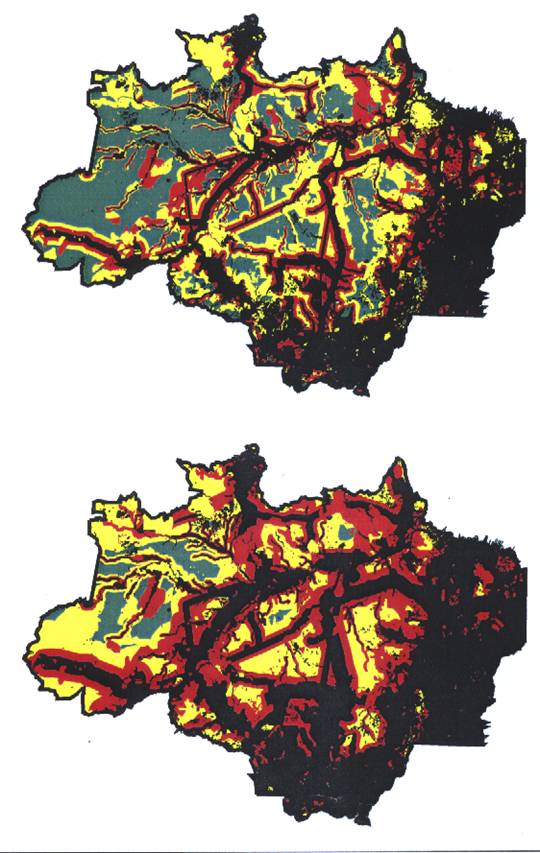
FIGURE CAPTION
Optimistic (above)
and non-optimistic (below) scenarios, showing predicted forest degradation by
the year 2020 (black is deforested or heavily degraded, including savannas and
other non-forested areas, while red is moderately degraded, yellow is lightly
degraded, and green is pristine).
THE FOLLOWING IS FOR ARCHIVAL ON
SCIENCE’S WEBSITE
The Future of the
Brazilian Amazon
Major Development Trends
There are at least four key proximate and ultimate drivers of deforestation in the Brazilian Amazon, as follows:
Rapid population growth. Poor economic conditions and droughts in northeastern Brazil, limited opportunities in large cities, the displacement of agricultural workers by mechanized farming, and government colonization programs designed to reduce urban overcrowding and help secure the Amazonian frontier have all contributed to a major influx of immigrants into the Amazon (1). In addition, Amazonian populations have high intrinsic growth rates. Although the traditionally high fertility rates of Amazonian women have declined somewhat in recent decades, the momentum of population growth will continue for some time because a large proportion of the population is young or still in their child-bearing years. Moreover, Amazonian residents typically begin bearing children early (in their mid-late teens or early twenties), which also contributes substantially to rapid population growth.
Industrial logging and mining. In addition to damaging forests and aquatic ecosystems directly, logging and mining activities create road networks that greatly increase access to forests for slash-and-burn farmers, ranchers, and hunters. The Amazon is becoming an increasingly important source of tropical timber. Brazil has nearly 400 domestic Amazonian timber companies, and there has been an influx of multinational timber corporations from Asia. Asian corporations invested over $500 million in the Brazilian timber industry in 1996 alone, and currently control at least 13 million ha of Amazonian forest (2). Petroleum, natural gas, and mineral resources (iron ore, bauxite, gold, copper) are providing a rapidly growing economic impetus for road building in the Amazon (3).
Changing Spatial Patterns of Deforestation. Since the 1960s, large-scale deforestation has been concentrated in the eastern and southern portions of the Brazilian Amazon--along the “arc of deforestation,” which encompasses parts of Pará, Rondônia, Acre, and Mato Grosso. There has also been forest clearing along rivers (especially white-water rivers such as the Solimões and Amazon that contain relatively fertile sediments) and in Roraima in northern Amazonia. But this picture is rapidly changing. Major new highways, powerlines, and transportation projects are now dissecting the heart of the basin, providing access to areas once considered too remote for development (2).
Wildfires. Tens of thousands of fires are lit each year by Amazonian ranchers and slash-and-burn farmers, leading to many serious wildfires, especially during periodic El Niño droughts (4-5). Logging and habitat fragmentation greatly increase the vulnerability of Amazonian forests to fires (6-8).
Explanation of the Models
Our geographic information system (GIS) models are designed to predict, at a relatively coarse spatial scale, the condition of Amazonian forests in the year 2020.
Data sources. To develop our models we used the most recent information available (Table 1). Data sources for forest cover, current roads and highways (Fig. 1), rivers, and conservation units were detailed maps produced by Brazilian agencies and conservation organizations, augmented with recent remote-sensing images and personal knowledge. Data on new highways, road upgrades, and planned infrastructure projects (Fig. 1) were gleaned from reports and internet data prepared by Avança Brasil (9), Brasil em Ação (10), and the 1998-2007 development plan for Eletrobrás (11), Brazil’s federal electricity utility. Zones of high, medium, and low forest-fire vulnerability were derived from a study that integrates extensive data on forest cover, seasonal soil-water availability, recent fires, and logging activity (12). Maps of the estimated extent of legal and illegal logging, industrial mining, and illegal gold mining were produced by IBAMA, Brazil’s national environmental agency (Table 1).
Protected areas. The Brazilian Amazon has 13 major types of federal and state conservation units that vary in their degree of environmental protection, which we placed into three categories (Table 2): (i) “high-protection reserves,” which nominally receive almost complete protection; (ii) “moderate-protection reserves,” which can be subjected to “sustainable” levels of industrial logging, agriculture, livestock grazing, hunting, fishing, and extraction of non-timber products; and (iii) “reserves with uncertain protection,” which are extensive indigenous lands that collectively comprise 17% of the Brazilian Legal Amazon. In some areas indigenous lands may be effectively protected, especially where Amerindians are territorial and repel illegal colonists, loggers, and gold miners. In other areas, however—particularly where Amerindians have frequent contact with outsiders—a corruption of traditional lifestyles can occur, sometimes leading to a sharp increase in forest exploitation (13,14). Hence, environmental protection in indigenous lands is likely to be highly variable, and will probably decline as contact with outsiders increases.
Modeling past deforestation. To predict the impacts of planned highways, roads, and infrastructure projects (15) over the next 20 years, we assessed the effects of existing highways and roads on primary-forest cover during a recent 15-25-year period (16). As expected, the analyses (Fig. 2) revealed that deforestation strongly increased near highways and roads. Both roads and highways averaged about 30% forest loss within the 0-10 km zone, but highways had more far-reaching effects than roads, averaging about 20% and 15% forest loss in the 11-25 and 26-50 km zones, respectively. Roads tended to cause more-localized deforestation, with average forest loss declining below 15% for areas further than 25 km from the road. The most far-reaching effects we observed were the construction of 200-300 km-long state and local roads ramifying out laterally from several major highways.
Land-use categories. We used these analyses to help generate “optimistic” and “non-optimistic” scenarios for the future of the Brazilian Amazon (17, 18). Our models predict the spatial distribution of four land-use categories: (i) “heavy-impact areas” have primary-forest cover that is absent or markedly reduced, and heavily fragmented; such areas are highly vulnerable to edge effects, fires, logging, and overhunting, and are severely degraded ecologically; (ii) “moderate-impact areas” have mostly intact primary-forest cover (>85%) but contain localized forest clearings and some roads, and may be affected by logging, mining, hunting, and oil and gas exploration; (iii) “light-impact areas” have nearly intact primary-forest cover (>95%) but can experience illegal gold-mining, small-scale farming, hunting, hand-logging, and non-timber resource extraction (e.g. rubber-tapping); and (iv) “pristine areas” have fully intact primary-forest cover and are free from anthropogenic impacts aside from limited hunting, fishing, and swidden farming by traditional indigenous communities.
Scenario assumptions. The sizes of degraded zones around highways, roads, rivers, and infrastructure projects have an empirical basis in our analyses of past deforestation (19). The optimistic and non-optimistic scenarios differ, however, in that the former assumes that degraded zones will be more localized (Table 3). The models also differ in terms of the future viability of protected areas: the optimistic scenario assumes that all reserves will remain pristine or only lightly degraded, whereas the non-optimistic model assumes that indigenous lands and moderate-protection reserves will become moderately degraded within 50 km of roads or 100 km of highways. The non-optimistic scenario also assumes that high-protection reserves will become lightly degraded near roads and highways (Table 3).
Results and
Interpretation
The optimistic scenario predicts that there will be continued deforestation in the southern and eastern portions of the Brazilian Amazon, and considerable large-scale fragmentation of forests in the central and southern parts of the basin. The Brazilian Amazon will be nearly bisected by heavily to moderately degraded areas along a north-south axis running from Rondônia to Manaus and northward to Venezuela. Pristine and lightly degraded forests will be fragmented into several blocks, with the largest tract surviving in the western Brazilian Amazon. According to this scenario, pristine forests will comprise just 27.6% of the region, with lightly degraded forests comprising another 27.5%. Almost 28% of the region will be deforested or heavily degraded (Fig. 3).
The
non-optimistic scenario projects an even more dramatic loss of forests along
the southern and eastern areas of the basin.
Large-scale fragmentation will also be more extensive, with much forest
in the central, northern, and southeastern areas persisting only in isolated
tracts. The basin will be almost
completely bisected by a swath of heavily degraded lands along the north-south
axis running from Rondônia to Venezuela.
There will be very few areas of pristine forest aside from those in the
western quarter of the region. This
scenario predicts that pristine forests will comprise just 4.7% of the region,
with lightly degraded forests comprising another 24.2%. Nearly 42% of the region will be deforested
or heavily degraded (Fig. 3).
Both of our models suggest that the Brazilian Amazon will be drastically altered by current development plans and land-use trends over the next twenty years. The principal difference between the models is in the extent of forest loss and fragmentation and relative proportions of heavily degraded versus pristine forests (Fig. 3).
Some degree of oversimplification in our models was inevitable. For example, we did not incorporate the effect of population density into our models, in part because we observed that local road density in the Amazon seemed to be a good surrogate for local population density. It is also apparent that the degraded zones around roads, highways, and infrastructure projects will be more variable spatially than is indicated in our models. While we incorporated many of the factors that are likely to influence local deforestation (e.g. distance to roads, road quality [paved vs. unpaved], presence and type of protected areas, vulnerability to forest fires, logging and mining activity), it is impossible to include every potentially relevant factor.
The optimistic and non-optimistic scenarios vary considerably, and at least three considerations suggest that the non-optimistic scenario may better approximate reality. First, the non-optimistic model realistically assumes that forests with high fire vulnerability will become heavily degraded, while those of moderate vulnerability will become moderately degraded. The model of fire vulnerability we used was produced for a normal dry season and is therefore conservative, in the sense that much larger areas of the Amazon become prone to fires during periodic El Niño droughts (4-7, 12).
Second, the non-optimistic model assumes that protected areas near highways and roads will be lightly to moderately degraded. In fact, many protected areas in the Amazon are little more than “paper parks” with inadequate protection. A recent analysis (20) of 86 federal parks and protected areas in Brazil found that 43% were at high to extreme risk because of illegal deforestation, colonization, hunting, isolation of the reserve from other forest areas, and additional forms of encroachment. More than half of all reserves (54.6%) were judged to have nearly non-existent management.
Finally, neither of our models incorporates possible synergistic effects that might occur as a result of large-scale forest conversion. Deforestation may substantially reduce regional rainfall because plant evapotranspiration is diminished when forests are converted to pastures or crops (21, 22) and because smoke particles from forest and pasture fires trap atmospheric moisture (23). Reduced atmospheric moisture can further result in decreased cloud cover and higher surface temperatures, especially in the dry season. These changes may make forests increasingly prone to fires, initiating a positive feedback cycle in which forest destruction exacerbates regional desertification which in turn promotes more forest fires (2, 4, 7). The nature of these positive feedbacks is poorly understood, but they could potentially accelerate forest destruction and might therefore cause our model predictions to be overly conservative.
Negative Effects of
New Roads and Infrastructure
What are the expected impacts of all the new highways and infrastructure projects? To address this question we re-ran our models without the Avança Brasil projects and other planned developments, and then compared the predictions to our original scenarios that included all the planned projects. Without the new projects, the rate of deforestation for the optimistic and non-optimistic models (24), respectively, declined by an average of 269,000 to 506,000 ha per year, while the rate at which pristine or lightly degraded forests are converted to moderately or heavily degraded lands slowed by 1.53-2.37 million hectares per year (Fig. 3). The new projects were also a major cause of forest fragmentation; under the non-optimistic scenario, for example, the area of the Brazilian Amazon that would persist in large (>100,000 km2) tracts of pristine to lightly degraded forest would be reduced by over 36% if the projects proceed as planned.
Carbon-offset funds from industrialized nations and private companies are likely to become an increasing important mechanism for promoting forest conservation and sustainable development in tropical regions (25). If the wave of planned projects did not proceed, we estimate that the financial value of the reduced carbon emissions alone would range from $0.52-1.96 billion per year (26), illustrating a clear potential for such revenues to improve living standards for local Amazonian communities. This is in addition to a range of other environmental services provided by intact forests, such as flood amelioration, soil conservation, the maintenance of stable rainfall regimes, preservation of biodiversity, benefits for ecotourism, and the support of indigenous communities (4, 27, 28). Finally, the social and economic costs that are often incurred in regions experiencing rapid deforestation, such as frequent airport closures and human health problems caused by heavy air pollution, recurring damage to crops and property from wildfires, and the need to maintain emergency fire-fighting capabilities (4, 7), would be substantially reduced.
References and Notes
1. G. Goodman and A. Hall, Eds., The Future of Amazonia: Destruction or Sustainable Development? (MacMillan, London, 1990).
2. W. F. Laurance, Trends Ecol. Evol. 13, 411 (1998).
3. P. M. Fearnside, in The Future of Amazonia: Destruction or Sustainable Development? G. Goodman and A. Hall, Eds. (MacMillan, London, 1990), pp. 179-225.
4. D. C. Nepstad et al., Nature 398, 505 (1999).
5. R. I. Barbosa and P.M. Fearnside, Acta Amazonica 29, 513 (1999).
6. C. Uhl, R. Buschbacher, Biotropica 17, 265 (1985).
7. M. A. Cochrane et al., Science 284, 1832 (1999).
8. C. Gascon, G. B. Williamson, G. A. B. da Fonseca, Science 288, 1356 (2000).
9. The Avança Brasil program (www.abrasil.gov.br) is designed to focus investments from international private and government sources on large-scale infrastructure projects that have been specifically targeted to accelerate economic development and exports (Avança Brasil: Development Structures for Investment [Ministry for Development, Industry, and Foreign Trade, Brasília, Brazil, 1999]). Our analysis also includes several major infrastructure projects (e.g. Xingu Dams beyond Belo Monte, Cuiabá-Santarém railway, Cuabá-Porto Velho railway, Aripuanã-Apuí-Novo Aripuanã highway, Perimetral Norte road) that are planned or were judged likely to proceed over the next 20 years.
10. Identificação
de Oportunidades de Investimentos Públicos e/ou Privados: Estudo de Eixos
Nacionais de Integração de Desenvolvimento (Programa Brasil em Ação, Brasília, Brazil, 2000).
11.
Eletrobrás: The Ten-Year Expansion
Plan, B, 1998-2007 (Centrais Elétricas do Brasil, Rio de Janeiro, Brazil,
1998).
12. It has been estimated that about 200,000 km2 of Brazilian Amazonian forest is vulnerable to fires during normal years, but this figure may approach 1.5 million km2 during periodic El Niño droughts (D. C. Nepstad et al., Conserv. Biol. 12, 951 [1998]).
13. In some cases, indigenous groups in Brazil have sold their timber to commercial loggers, permitted wildcat mining, overhunted wildlife, illegally cleared protected lands, invaded national parks, impeded firefighters, and even assaulted government inspectors attempting to control illegal logging (M. Margolis, Newsweek International, 27 March, pp. 10-14 [2000]).
14. There has been considerable debate about the efficacy of indigenous lands in the Amazon for nature conservation (e.g. K. H. Redford, A. M. Stearman, Conserv. Biol. 7, 427 [1993]).
15. Road networks are generated by infrastructure projects, as it is nearly impossible to construct hydroelectric dams, powerlines, gaslines, and other major facilities without road access.
16. To do this we overlayed the 1995 road network on the Landsat Thematic Mapper-based Pathfinder map of the Brazilian Amazon for 1992. Many of the region’s major highways (e.g. Belém-Brasília, Transamazon, BR-364) were constructed in the 1960s and 1970s, and thus had been in existence for 15-25 years by 1992, comparable to the 20-year time frame for our predictions. Initially, five “degradation zones” were created around all paved highways (0-10, 11-25, 26-50, 51-75, and 76-100 km on each side of the highway), and the percentage loss of primary-forest cover within each zone was determined. This analysis was then repeated using the entire network of highways and unpaved roads. Clouds, cloud shadows, and rivers were excluded from the analysis (<5% of total area). Zones were truncated if they passed outside the Brazilian Legal Amazon. Deforestation was registered only for closed-canopy forests; losses of other habitats (e.g. savanna) were not included. Analyses were run on a Silicon Graphics Origin 2000 supercomputer at the Basic Science and Remote Sensing Initiative, Michigan State University.
17. All maps and spatial data were georeferenced to a geographic coordinate system, using Imagine 8.3 software. Subsequently, georeferenced digital images were used for vector data-layer construction, using ArcInfo 7.2 with heads-up digitizing methods. Road and infrastructure buffers were created with ArcInfo for the appropriate distances. Data layers were integrated with overlay methodology. Most analyses were performed on a Silicon Graphics Indigo2 workstation at the headquarters of the Biological Dynamics of Forest Fragments Project in Manaus, Brazil.
18. In our analyses we assumed that the forests of the Brazilian Legal Amazon (composed of 19 forest formations, mostly closed-canopy forests) spanned 4.0 million km2 prior to European colonization (Deforestation in Brazilian Amazonia [Instituto Nacional de Pesquisas Espaciais, San Jose dos Campos, Brazil, 1992]).
19. In the non-optimistic scenario, for example, we assumed that paved highways would create a 50 km-wide zone of heavily degraded forests on each side (Table 3), because our analysis suggested that these areas averaged <85% forest cover (Fig. 1). Such areas would be prone to logging, fragmentation, fires, edge effects, and other ecological changes that could affect much of the remaining forest cover (W. F. Laurance et al., Science 278, 1117 [1997]; also see references 4, 7, and 8). Likewise, we conservatively assumed that the lightly degraded zone would extend 100-200 km from paved highways (Table 3), because we observed many roads stretching at least 200 km from existing highways.
20. L. V. Ferreira et al., Áreas Protegidas ou Espaços Ameaçados? (World Wide Fund for Nature, Brasília, Brazil, 1999).
21. J. Lean and D. A. Warrilow, Nature 342, 411 (1989).
22. J. Shukla, C. A. Nobre, and P. Sellers, Science 247, 1322 (1990).
23. D. Rosenfeld, Geophys, Res. Letters 6, 3105 (1999).
24. To estimate the amount of deforestation that can be directly attributed to the planned highways and infrastructure projects, we multiplied the expected increase in each forest-degradation category (Fig. 3) by the average percent forest loss in each category, based on analyses of past deforestation near highways and roads. These values were then summed and divided by 20, yielding a rough prediction of annual deforestation from these projects over the next 20 years. Because forest loss is spatially variable, we developed three different estimates of past deforestation—for Rondônia, the eastern Brazilian Amazon (east of 50o W longitude), and the entire Brazilian Amazon (Table 4)—and used the mean of these three estimates in our calculations.
25. C. Kremen et al., Science 288, 1828 (2000).
26. The most plausible estimates suggest that carbon offsets will range from US$10-20 ton-1 in value over the next decade (P. M. Fearnside, in Global Climate Change and Tropical Ecosystems. R. Lal, J. Kimble, R. Steward, Eds. [CRC Press, Boca Raton, Florida, 2000], pp. 231-249). We multiplied the projected values of carbon offsets ($10-20 ton-1) by the annual increases in deforestation attributable to the planned highways and infrastructure projects (269,047 to 505,846 ha; Table 4), and by the average net emissions of CO2-equivalent carbon from Amazon deforestation (194 metric tons ha-1). If carbon offsets are $10 ton-1, then the destroyed forests would be worth $0.52-0.98 billion per year. If carbon offsets are $20 ton-1, however, then the destroyed forests would be worth twice as much ($1.04-1.96 billion yr-1).
27.
P. M. Fearnside, Ecol. Economics
21, 53 (1997).
28. M. J. Balick and R. Mendelsohn, Conserv. Biol. 6, 128 (1992).
29. L. L. Silva, Ecologia: Manejo de Áreas Silvestres (Ministério do Meio
Ambiente, Brasília, Brazil, 1996).
30. F. Olmos, A. P. Queiroz-Filho, C. A. Lisboa, As Unidades de Conservação de Rôndonia
(Secretaria de Planejamento, Rondônia, Brazil, 1998).
31. A. B. Rylands, L. P. Pinto, Conservação da Biodiversidade na Amazônia
Brasiliera: Uma Análise do Sistema de Unidades de Conservação (Fundação
Brasileira para o Desenvolvimento Sustentável, Brasília, Brazil, 1998).
32. S. H. Borges, M. Pinheiro, A. Murchie, C.
Durigan, in As Florestas do Rio Negro, A.
Oliveira and D. Daly, Eds. (Universidade Paulista Press, São Paulo, Brazil,
2000).
33. Information on protected areas was partly gleaned from Internet websites of the Brazilian Institute for the Environment and Renewable Natural Resources (IBAMA), Instituto Socio-Ambiental, and Brazilian Institute for Geography and Statistics (IBGE); and communication with Luciene Pohl of Brazil’s National Indian Foundation (FUNAI).
Table 1. Data layers used in analyses of land-use trends in Brazilian Amazonia. Infrastructure projects include railroads, hydroelectric reservoirs, powerlines, gaslines, and river-channelization projects.
Layer Data Sources
Current forest cover and rivers Forest/non-forest coverage produced by the National
Oceanographic and Atmospheric Administration
based on 1999 AVHRR imagery
Existing highways (paved) and 1995 map of Brazilian Legal Amazon (1:3,000,000
roads (unpaved) scale) produced by Brazilian Institute for Geography
and Statistics (IBGE); supplemented by 1999 map of
Amazonian protected areas (1:4,000,000 scale, Instituto Socio-Ambiental, São Paulo, Brazil), JERS-1 radar imagery for 1999, and personal knowledge
Planned roads and highways, Maps and information provided by Avança Brasil (9), and highway upgrades Brasil em Ação (10), and personal knowledge
Existing infrastructure projects 1995 IBGE map of Brazilian Legal Amazon, and personal knowledge
Planned infrastructure projects Maps and information provided by Avança Brasil (9), Brasil em Ação (10), Eletrobrás (11), and personal knowledge
Fire proneness of forests Map of areas with high, medium, and low fire
vulnerability, based on analyses of forest cover, seasonal soil moisture, logging activity, and recent fires during the1998 dry season (12)
Logging and mining activity 1998 map of estimated legal and illegal logging,
wildcat gold mining, and industrial mining, produced by IBAMA, Brazil’s national environmental agency
Federal and state parks and 1995 IBGE map of Brazilian Legal Amazon,
reserves, national forests, supplemented by 1999 map of Amazonian protected
extractive reserves, and areas and personal knowledge
indigenous lands and reserves
Table 2. Legally permitted activities within protected and semi-protected areas in the Brazilian Amazon (29-33).
Recreation Agriculture Non-timber
Type of Area & Tourism & Livestock Logging Harvests Hunting Mining
Areas with nominally high protection
National/State
Parks Yes No No No No No
Ecological
Reserves Yes No No
No No No
Biological
Reserves No No No No No No
Ecological
Stations No No No No No No
Areas with moderate protection
National/State Forests Yes Yes Yes Yes Yes1 No National Forest Res. Yes Yes Yes Yes Yes1 No
Extractive Reserves Yes Yes Yes Yes Yes1 No
State Extractive Forests Yes Yes Yes Yes Yes1 No
Sustainable Use Forests Yes Yes Yes Yes Yes1 No
Sustain. Devel. Reserves Yes Yes Yes Yes Yes1 No
Environ. Protection Areas Yes Yes2 Yes2 Yes2 No Yes2
Areas of Relevant
Ecological Interest Yes Yes2 No Yes2 No No
Areas with uncertain protection
Indigenous Lands and
Reserves No Yes Yes Yes Yes No
1Hunting is allowed in some areas; for others information was unavailable.
2These activities are not expressly permitted, but because people are allowed to live in these reserves they will certainly occur, at least on a limited scale.
Table 3. Explicit assumptions of “optimistic” and “non-optimistic” GIS models to predict
the future of the Brazilian Amazon.
Optimistic Scenario Non-optimistic Scenario
1) Degradation zones
around paved highways (current and planned)
Heavily degraded zone 0-25 km 0-50 km
Moderately degraded zone 25-50 km 50-100 km
Lightly degraded zone 50-75 km 100-200 km
Pristine zone >75 km >200 km
2) Degradation zones around unpaved roads, railroads, powerlines, gaslines, industrial mines, and river-channelization projects (current and planned)
Heavily degraded zone 0-10 km 0-25 km
Moderately degraded zone 10-25 km 25-50 km
Lightly degraded zone 25-50 km 50-100 km
Pristine zone >50 km >100 km
3) Degradation zones around
hydroelectric reservoirs
Heavily degraded zone Area inundated Area inundated
Moderately degraded zone 0-5 km 0-10 km
Lightly degraded zone 5-10 km 10-25 km
Pristine zone >10 km >25 km
4) Degradation zones
around major navigable rivers (>900 m wide)
Heavily degraded zone 0-2 km 0-5 km
Moderately degraded zone 2-5 km 5-10 km
Lightly degraded zone 5-10 km 10-25 km
Pristine zone >10 km >25 km
5) Areas prone to logging Moderately degraded Mod. degraded
6) Areas prone to wildcat mining Lightly degraded Lightly degraded
7) Areas prone to
fires
High vulnerability Moderately degraded Heavily degraded
Moderate vulnerability Lightly degraded Mod. degraded
8) Conservation areas
High-protection areas outside buffers Pristine Pristine
High-protection areas inside buffers Pristine Lightly degraded
Mod.-protection areas outside buffers Lightly degraded Lightly degraded
Mod.-protection areas inside buffers Lightly degraded Mod. degraded
Indigenous areas outside buffers Pristine Lightly degraded
Indigenous areas inside buffers Lightly degraded Mod. Degraded
Table 4. Expected
increases in total, annual, and percentage deforestation rates in the Brazilian
Amazon over the next 20 years as a result of planned highways and
infrastructure projects. The “percent
increase” is relative to the current mean deforestation rate (1.89 million ha
yr-1 for the 1995-1999 period).
Estimates are shown for two development scenarios (optimistic and non-optimistic),
based on assessments of past deforestation in three different study areas
(Rondônia/BR-364 Highway; eastern Brazilian Amazon; entire Brazilian
Amazon). The mean value of the three
scenarios was used in this study.
______________________________________________________________________
Total Increase (ha) Annual Increase (ha yr-1) Percent Increase
Study Area Optimistic Non-opt. Optimistic Non-opt.
Optimistic Non-opt.
______________________________________________________________________
Rondônia/BR-364
5,658,598 9,902,779 282,930
495,139 15.0 26.2
Eastern Amazon
7,055,033 12,871,555 352,752
643,578 18.7 34.1
(east of 50o W)
Entire Amazon
3,429,200 7,576,400 171,460
378,820 9.1 20.0
Mean
5,380,944 10,116,911 269,047
505,846 14.3 26.8
______________________________________________________________________
FIGURE CAPTIONS
Fig. 1. Existing and planned highways and infrastructure projects in the Brazilian Amazon. Above: highways and roads. Below: major infrastructure projects; “utilities” are gaslines and powerlines, while “channels” are river-channelization projects.
Fig. 2. Percentage of closed-canopy forest destroyed by 1992 as a function of distance from paved highways, and from all roads and highways, in the Brazilian Amazon.
Fig. 3. Above: percentages of Brazilian Amazon forest in various degradation classes according to the optimistic and non-optimistic scenarios. Below: results of the same scenarios generated without planned highways and infrastructure projects.