The text that follows is a PREPRINT.
Please cite
as:
Fearnside, P.M. 2003. Deforestation control in Mato
Grosso: A new model for slowing the loss of Brazil’s Amazon forest. Ambio 32(5): 343-345.
ISSN: 0044-7447
Copyright: Royal Swedish Academy of Sciences
The original
publication is available at: <Ambio>
Deforestation Control in
Mato Grosso: A New Model For Slowing the Loss of Brazil’s Amazon Forest
Philip M. Fearnside
Department of
Ecology
National
Institute for Research in the Amazon (INPA)
Av.
André Araújo, 2936
C.P.
478
69011-970
Manaus, Amazonas
Brazil
Fax: +55-92-642-8909
Tel:
+55-92-643-1822
e-mail:
pmfearn@inpa.gov.br
Number of words in main text: 2184
Figures: 5
Ability to receive pdf files: yes
6
August 2002
Revised: 4 November 2002
INTRODUCTION
Deforestation
in Brazilian Amazonia continues to proceed at high rates, as it has since the
early 1970s when key highways were built that provide access to the region from
other parts of Brazil (1). Since 1988,
Brazil’s National Institute for Space Research (INPE) has, with only one
exception, made annual estimates of deforestation in the region using LANDAT
satellite imagery (2). The annual
announcement of these results is frequently accompanied by announcements of new
“packages” of control measures, especially when the deforestation rate turns
upward. In the succeeding years,
however, deforestation rate appears to increase or decrease largely independent
of these measures. Macro-economic
changes affecting investment decisions appear to have much stronger influence
on regional deforestation trends than any federal control measures (3). Now, a state-level program to license and
control deforestation in Mato Grosso (Fig. 1), which has long been one of the
Amazonian states with the highest deforestation rates, provides an indication
that this need not continue to be the case.
[Figure
1 here]
The experience in Mato Grosso takes
on special importance in the context of Brazil’s negotiating positions on the
Kyoto Protocol. Brazil’s negotiators
have consistently opposed awarding credit for avoided deforestation, although
they have supported credit for other forest-sector activities such as
plantations. The fundamental reason is
believed to be the fear among key individuals that accepting credit for avoided
deforestation could expose Brazil to international pressures that would
threaten the country’s sovereignty over the region if Brazil were to take on
commitments for emissions reductions that it subsequently was unable to meet
(4, 5). The basic problem is a lack of
confidence that deforestation can be controlled. From 1997 to 2000 deforestation rates in the
Legal Amazon continually crept upward.
The events in Mato Grosso suggest that government measures are capable
of influencing deforestation, and the process is not inherently
uncontrollable. This is a potentially
important development for negotiations to begin in 2005 regarding the future of
the Protocol after its first commitment period ends in 2012.
THE MATO GROSSO LICENSING AND CONTROL SYSTEM
The Mato Grosso’s State Foundation for the
Environment (FEMA) has been implementing a program to license and control
deforestation since 1999 (6). Mato
Grosso is in the process of bringing landowners into compliance with existing
legislation, such as Brazil’s “Forestry Code.”
Shortcomings of the Forestry Code for conservation purposes are well
known, but efforts to improve it are complicated by intense pressure from
farming and ranching lobbies to weaken environmental protection (7, 8). The long traditions of impunity and of
government inability to enforce any set of regulations in practice (9) make
demonstration of enforcement effectiveness especially important in the process
of bringing Amazonian development under the rule of law.
Since 2000, federal requirements specify that
the “legal reserve” of native vegetation that must be maintained in each
property (or in registered lands elsewhere) equal to 80% of the property in
forest and 35% in cerrado (central Brazilian savanna) areas. A Mato Grosso state government decision
specifies 50% in the “transition” area—the ecotone between the forest and the cerrado. The cerrado is located in the southern
part of the state, the forest in the north, and the transition in the
center. Clearing of forest and
transition are considered to be “deforestation” by INPE, while clearing of is cerrado
not. INPE terminology is adopted in the
present paper.
Prior to field campaigns, illegal clearings are
identified on satellite imagery, after which technicians are sent to inspect specific
clearings. LANDSAT-TM imagery in digital
form is interpreted manually (the image is magnified on a computer screen, and
a cursor traced over the features), allowing detection of clearings as small as
1 ha. Using a global positioning system
(GPS), the FEMA technicians are able to locate the clearing and the property
headquarters in the field (Fig. 2).
Public Internet access to information on registered properties and their
owners, including identification of violators, is a new addition to the system. The site (10) lists properties without
infractions in blue and violators in red.
“Clicking” on a property in the list brings up the personal information
on the owner and a map of the property, showing the legal reserve, area of
permanent protection (stream banks and steep slopes), and legal and illegal
clearings.
[Fig.
2 here]
The responsibility for licensing clearing is
divided between FEMA and the Brazilian Institute for the Environment and
Renewable Natural Resources (IBAMA) based on an agreement known as the
“federative pact,” under which FEMA licenses clearings over 200 ha, while IBAMA
licenses smaller clearings. Most
clearing in Mato Grosso has been illegal so far. Only 40 000 ha in clearings > 200 ha in
area was authorized by FEMA in 2000-2001.
The illegal clearing can therefore be calculated by subtracting this
area from the > 200 ha total (789 004 ha in the biennium). Illegal clearings > 200 ha in area
therefore total approximately 750 000 ha, or 95%.
The sizes of clearings provide an important
indication of the relative importance of small versus large landholders.
Only 36% of the area cleared in the 2000-2001 biennium was in clearings
up to 100 ha, while 64% was clearings larger than 100 ha. Most of the clearings under 100 ha in area
also represent the work of large landholders, as small farmers using family
labor clear an average of only about 3 ha family-1 yr-1
(11). Clearings 1-6.25 ha in area
represented only 2% of the total area of new clearing detected in
2000-2001. The dominant role of large
clearings is critical in making it possible to significantly reduce
deforestation rates without affecting poor farmers who depend on subsistence
agriculture for survival (12).
INDICATIONS OF PROGRAM EFFECTS ON DEFORESTATION
Deforestation (forest and transition clearing)
in Mato Grosso can be compared to that in the rest of the Legal Amazon region
through 2000, based on INPE estimates (13).
The state-level data indicate that Mato Grosso was following or
exceeding the general trends in the region through 1999. During the following year (2000),
deforestation declined in Mato Grosso while it increased in the rest of the
Legal Amazon (Fig. 3), providing an indication that the program was having an
effect.
[Fig.
3 here]
According to the FEMA data, the rate of
deforestation in Mato Grosso in forest and transition areas declined by 35% in
the 2000-2001 biennium relative to the rate in the 1998-1999 biennium (1999
marks the beginning of the licensing program).
However, prior to 1999 the rate was either already declining (according
to FEMA data, Fig. 4) or beginning to increase less steeply (according to INPE
data, Fig.3). The difference between
INPE (Fig. 3) and FEMA (Fig. 4) data for the period before 1999 is unexplained:
INPE indicates a 13.7% increase in deforestation (forest + transition clearing)
from 591 ´ 103 ha yr-1 in the 1996-1997 biennium to 671 ´ 103 ha yr-1 in
1998-1999, whereas FEMA finds a 17.1% decrease from 770 ´ 103 ha yr-1 to 638 ´ 103 ha yr-1 between the
same periods. However, the downturn
after 1999 is indicated by both agencies.
The decline or slackening of deforestation prior to 1999 stems from
exhaustion of available land for clearing in some parts of the state, while at
least part of the additional decline after 1999 appears to reflect the
licensing and control program.
[Fig.
4 here]
The annual rate of loss of original vegetation
in Mato Grosso, based on FEMA data, indicates declines varying by vegetation
type (Fig. 4). Both the rate of loss of
forest and transition (i.e., deforestation) and the rate of cerrado
clearing declined throughout the period, according to the FEMA data. In the case of cerrado, the decline is
less steep in the second biennium (i.e., after the licensing system began),
possibly because most of the land in cerrado areas without agricultural
impediments, such as steep slopes, had already been cleared. In the case of forest and transition, the
decline is steeper in the second biennium, consistent with an effect from the
program.
The sharpest downturn was in the transition
zone, where the rate declined by 43.7% for the 2000-2001 biennium as compared
to 1998-1999; this corresponds to the zone in the middle of the state that
received the most enforcement effort. By
contrast the cerrado, located in the southern part of the state, had a
downturn in clearing rate of 32.7%, while the forest zone in the far north had
a downturn of 31.9%. The greater decline
in the transition area as compared to the forest appears to be best explained
by the level of enforcement, while the contrast of these areas with the cerrado
probably results from frontier age.
![]()
Trends at the county level reveal
differences depending on the predominant land use and the age of the
frontier. In old soybean areas (e.g.,
Fig. 5a, where 75.3% of the county had been cleared by 2001), the exhaustion of
forest areas suitable for clearing was already causing clearing rates to
decline before the 1999 initiation of the licensing program. Following beginning of the program, clearing
continued at its (relatively) low plateau.
In contrast, in a newer soybean frontier (Fig. 5b), with 32.8% of the
county cleared by 2001, clearing rates were increasing strongly prior to the
program, but the trend reversed thereafter.
[Fig.
5 here]
In old ranching areas, (e.g., Fig.
5c, where 72.2% of the county had been cleared by 2001), clearing rates were
declining prior to 1999 and continued the same declining trend thereafter. In new ranching areas (e.g., Fig. 5d, where
5.1% of the county had been cleared), clearing rates were increasing prior to
initiation of the program, and the trend reversed thereafter. As with the soybean areas, the reversal is
suggestive of an effect from the control program.
County-level trends in settlement
areas also indicate reversals in newer areas, although the effect is likely to
be due to larger ranches located in the same counties. In an old area of small-farmer settlements
(Fig. 5e), where 38.4% of the county had been cleared by 2001, the rate of loss
was declining prior to 1999 and continued the same declining trend
thereafter. In a newer settlement
frontier (Fig. 5f), with 16.6% of the county cleared by 2001, clearing rates
were increasing prior to initiation of the program in 1999, and the trend
reversed thereafter.
Trends in counties with contrasting
levels of enforcement effort also indicate an effect of the program. In an area where virtually no enforcement was
carried out through 2001 (Fig. 5g, 20.1% cleared by 2001), clearing rates were
declining prior to initiation of the program in 1999, but the decline did not
continue at the same rate thereafter. In
an area with a high level of enforcement effort (Fig. 5h, 44.5% cleared by
2001), clearing was declining slightly prior to 1999, but the decline increased
sharply after initiation of the enforcement program.
EXTENSION TO OTHER STATES
On 26 February 2002, Brazil’s
minister of the environment announced that a “system of licensing of rural properties”
would be extended to all of Amazonia based on the experience in the Mato
Grosso. Important differences are
evident among the states as to official commitment to reducing deforestation. Acre and, until recently, Amapá have had a
reputation for being the states that give greatest priority to the environment,
while Maranhão, Rondônia and Roraima give the least. At the local (county) level, some mayors have
adopted governance policies that could act to complement state and federal
efforts (13). In any state, this
priority can change radically as different governors come and go. One way to provide protection of the system
against unfavorable state governments would be to have a federal center in
Brasilia, such as IBAMA or some other part of the Ministry of the Environment,
process the data on clearing and/or maintain a mirror image of the data base
from the state-level agencies. This
would help to reduce some of the differences among states and among gubernatorial
administrations within any given state.
In Brazil’s October 2002 elections,
Blairo Maggi, the largest soybean entrepreneur in Brazil (and probably in the
world), was elected governor of Mato Grosso for the 2003-2006 period. While this change is likely to result in a
weakening or loss of political commitment to the environmental licensing
program at the state level in Mato Grosso, federal authorities and the judicial
system continue to have responsibility for enforcement of environmental laws
throughout Brazil, including Mato Grosso.
Regardless of the fate of the licensing system in Mato Grosso, its
demonstration of the ability of government to limit deforestation has important
implications for all of Amazonia.
CONCLUSIONS
The trends in Mato Grosso suggest
an effect of licensing and control in reducing clearing rates. Together with programs to enhance the
attractiveness of activities that maintain forest cover, including tapping the
value of the environmental services of standing forest, licensing and control
programs are essential to the government’s ability to redirect development in
the region along more sustainable and less environmentally damaging lines. While deforestation in Brazil’s Amazon region
is by no means “under control,” the events in Mato Grosso show that government
action is capable of slowing forest loss (14).
References and Notes
1. Fearnside, P.M. 1986.
Spatial concentration of deforestation in the Brazilian Amazon. Ambio 15, 72-79.
2. Brazil, INPE
(Instituto Nacional de Pesquisas Espaciais) 2002. Monitoramento da Floresta
Amazônica Brasileira por Satélite/Monitoring of the Brazilian Amazon Forest by
Satellite: 2000-2001. INPE, São José dos Campos, São Paulo, Brazil. 23 pp.http://www.inpe.br. (in Portuguese and
English).
3. Fearnside, P.M. 2002. Amazonia, Deforestation of. In: Encyclopedia of Global Change: Environmental Change and Human Society, Vol. 1. Goudie, A.S. and Cuff, D.J. (eds) Oxford University Press, New York, U.S.A. pp. 31-38.
4. Fearnside, P.M. 2001. Saving tropical forests as a global warming
countermeasure: An issue that divides the environmental movement. Ecolog. Econ. 39, 167-184.
5. Fearnside, P.M. 2001. The potential of Brazil's forest sector for
mitigating global warming under the Kyoto Protocol. Mitig.
Adapt. Strat. Global Change 6, 355-372.
6. Mato Grosso, Fundação Estadual do Meio
Ambiente (FEMA) 2001. Environmental
Control System on Rural Properties in Mato Grosso. FEMA, Cuiabá, Mato Grosso, Brazil. 45 pp.
7. Amigos da Terra-Amazônia
Brasileira. 2002. Código
Florestal. http://www.amazonia.org.br/guia/detalhes.cfm?id=13291&tipo=6&cat_id=39&subcat_id=159.
(in Portuguese).
8. Fearnside, P.M. 2001. Soybean
cultivation as a threat to the environment in Brazil. Environ. Conserv. 28,
23-38.
9. Rosenn, K.S. 1971. The jeito: Brazil's institutional bypass of the
formal legal system and its development implications. Am. J. Compar. Law
19, 514-549.
10. Mato Grosso, Fundação Estadual do Meio
Ambiente (FEMA) 2002. Untitled
website. FEMA, Cuiabá, Mato Grosso, Brazil.http://200.163.61.50/pls/publico/ovigianet.index_ovigianet.
(in Portuguese).
11. Fearnside, P.M. 1984. Land clearing
behaviour in small farmer settlement schemes in the Brazilian Amazon and its
relation to human carrying capacity. In: Tropical Rain Forest: The Leeds
Symposium Chadwick, A.C. and Sutton,
S.L. (eds) Leeds Philosophical and Literary Society, Leeds, U.K. pp. 255-271.
12. Fearnside, P.M. 1993. Deforestation in
Brazilian Amazonia: The effect of population and land tenure. Ambio 22, 537-545.
13. Nepstad, D., McGrath, D., Alencar,
A., Barros, A.C., Carvalho, G., Santilli, M. and Vera Diaz, M. del C. 2002. Frontier governance in Amazonia. Science 295,
629.
14. This work is supported by
CNPq (Proc. 470765/01-1). PPG7-SPRN
provided travel support. R.I. Barbosa and G.L. Ferreira made valuable comments.
FIGURE LEGENDS
Figure 1 The
nine states in Brazil’s 5 ´ 106
km2 “Legal Amazon” region.
Figure 2 FEMA
technicians examine satellite image (left) and deforestation permit (right) in
the field on an inspection mission in Ipiranga do Norte County. The pink areas in the satellite image are
cleared fields (mostly soybeans), the green is forest and the brown areas to
which the technicians are pointing are recent clearings. The man at the left is pointing to a legal
clearing authorized by the deforestation permit being held by the man at the
right (the yellow line indicates authorized clearing and the white line the
“legal reserve”). The man at the back is
pointing to a clearing in a neighboring property with no FEMA permit. (Photo by
P.M. Fearnside).
Figure 3 Deforestation
(clearing of forest and transition) in Mato Grosso (♦) compared to the
rest of the Legal Amazon region (€) based on INPE (2) estimates.
Figure 4 Annual rate of
loss of original vegetation in Mato Grosso, based on FEMA data. Both the rate of loss of forest (Ž) and transition (•)(i.e., deforestation) and the rate of cerrado
clearing (€) declined throughout the period. Because
clearing rates were already declining since before the beginning of the program
in 1999, examination of smaller areas is needed to separate program effects
from those of frontier aging.
Figure 5 County-level trends in loss of original vegetation in areas with
different land-use types, frontier ages and enforcement histories: a
Rondonópolis, an old soybean frontier; b Ipiranga do Norte, a new soybean
frontier; c Colider, an old ranching frontier; d Aripuanã, a new
ranching frontier; e Alta Floresta, an old small-farmer settlement
frontier (also including some large ranches); f Juruena, a new
small-farmer settlement frontier (also including some large ranches); g
Cáceres an area with a low level of enforcement effort, and h Sinop, an
area with a high level of enforcement effort.
ABSTRACT
Controlling
deforestation in Brazil’s Amazon region has long been illusive despite repeated
efforts of government authorities to slow the process. From 1997 to 2000, deforestation rates in
Brazil’s nine-state “Legal Amazon” region continually crept upward. Now, a licensing and enforcement program for
clearing by large farmers and ranchers in the state of Mato Grosso appears to
be having an effect. The deforestation
rate in Mato Grosso was already beginning to slacken before initiation of the
program in 1999, but examination of county-level data suggests that
deforestation in already heavily cleared areas was falling due to lack of
suitable uncleared land, while little-cleared areas were experiencing rapid
deforestation. Following initiation of
the program, the clearing rates declined in the recent frontiers. Areas with greater enforcement effort also
appear to have experienced greater declines.
Demonstration of government ability to enforce regulations and influence
trends is important to domestic and international debates regarding use of
avoided deforestation to mitigate global warming.
BIOGRAPHY
Dr. Philip M.
Fearnside is a research professor at the National Institute for Research in the
Amazon (INPA). He works on human
carrying capacity, the rates, causes and impacts of deforestation, and the
sustainability of different modes of development. His address: INPA, Caixa
Postal 478, 69011-970 Manaus, Amazonas, Brazil.
E-mail:
pmfearn@inpa.gov.br
Fig. 1
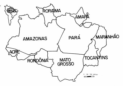
Fig. 2
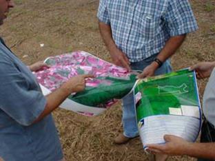

Fig. 3
Fig. 4
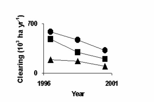
Fig. 5

![]()
![]()
![]()
![]()

![]()
![]()
![]()
![]()
![]()
![]()
